Attēls:161 Système allemand de radio-navigation Bernhart (2e guerre mondiale).JPG
Pāriet uz navigāciju
Pāriet uz meklēšanu

Šī priekšskata izmērs: 403 × 600 pikseļi. Citi izmēri: 161 × 240 pikseļi | 322 × 480 pikseļi | 516 × 768 pikseļi | 688 × 1 024 pikseļi | 2 240 × 3 333 pikseļi.
Sākotnējais fails (2 240 × 3 333 pikseļi, faila izmērs: 1,45 MB, MIME tips: image/jpeg)
.JPG)
Kopsavilkums
| Apraksts |
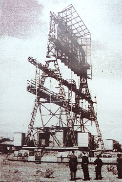
Français : Système allemand de radionavigation "Bernhart" au mont Les Justices en Vendée (2e guerre mondiale) |
| Datums | |
| Avots | Paša darbs |
| Autors | Henri MOREAU |
Licence
|
This work is in the public domain in its country of origin and other countries and areas where the copyright term is the author's life plus 70 years or fewer. | |
| This file has been identified as being free of known restrictions under copyright law, including all related and neighboring rights. | |
Faila hronoloģija
Uzklikšķini uz datums/laiks kolonnā esošās saites, lai apskatītos, kā šis fails izskatījās tad.
| Datums/Laiks | Attēls | Izmēri | Dalībnieks | Komentārs | |
|---|---|---|---|---|---|
| tagadējais | 2010. gada 9. oktobris, plkst. 05.41 | | 2 240 × 3 333 (1,45 MB) | wikimediacommons>Moreau.henri | {{Information |Description={{fr|1=Système allemand de radionavigation "Bernhart" (2e guerre mondiale)}} |Source=own |Author=Henri MOREAU |Date=2010 |Permission=yes |other_versions= }} Category:World War II [[Category:Mont Saint-Michel de Brasparts] |
Faila lietojums
Šo failu izmanto šajā 1 lapā:
.JPG)